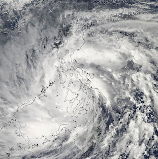
MANILA, Philippines - Super typhoon Yolanda (international codename Haiyan) has made a mark as one of the planet's most catastropic storms.
The winds of the super typhoon brought monster winds and giant waves that left a massive trail of death and destruction in various parts of the country.
How does this super typhoon compare with other strong cyclones in earth's history? Rappler looked at various indicators:
Wind speed
Jeff Masters, Director of Meteorology for the website Weather Underground, described Yolanda/Haiyan to have achieved maximum sustained winds of 195 miles per hour (315 k/h) near the eye, thereby positioning it as among the strongest cyclones in the world in terms of wind stregth.
Typhoon Nancy (1961) - 215 miles per hour (346 k/h)
Typhoon Violet (1961) - 205 miles per hour (330 k/h)
Typhoon Ida (1958) - 200 miles per hour (322 k/h)
Typhoon Haiyan (2013) - 195 miles per hour (315 k/h)
Typhoon Kit (1966) - 195 miles per hour (315 k/h)
Typhoon Sally (1964) - 195 miles per hour (315 k/h)
Typhoon Tip (1979) - 190 miles per hour (306 k/h)
Hurricane Allen (1980) - 190 miles per hour (306 k/h)
Hurricane Camille (1969) - 190 miles per hour (306 k/h)
Hurricane Vera (1959) - 190 miles per hour (306 k/h)
Hurricane Sarah (1959) - 190 miles per hour (306 k/h)
But since estimates for typhoons from 1940s to 1960s are now considered too high, Yolanda/Haiyan now makes it to the top of the list.
Masters also described the super typhoon as "the strongest tropical cyclone on record to make landfall in world history," beating the record of the 1969 Hurricane Camille.
Typhoons Nancy, Violet, and Ida also made landfall, but their wind speed decreased prior to hitting land.
Central pressure
Other statistics determine the intensity of a tropical cyclone through its minimum central pressure.
An article in the Autralian Geographic states: "The lower the pressure, the more air gets sucked in to the cyclone, and ultimately it will have more power."
In this department, Yolanda/Haiyan recorded a minimum central pressure of 895 hectopascal (hPa). The super typhoon is behind other cyclones recorded by the Japan Meteorological Agency (JMA) and the National Oceanic and Atmospheric Administration (NOAA) that had lower numbers.
Typhoon Tip (1979) - 870 hPa
Typhoon Nora (1973) - 875 hPa
Typhoon June (1975) - 875 hPa
Typhoon Ida (1958) - 877 hPa
Typhoon Kit (1966) - 880 hPa
Typhoon Rita (1978) - 880 hPa
Typhoon Vanessa (1984) - 880 hPa
Hurricane Wilma (1953) - 882 hPa
Typhoon Nina (2005) - 885 hPa
Typhoon Joan (1959) - 885 hPa
Typhoon Irma (1971) - 885 hPa
Typhoon Forrest (1983) - 885 hPa
Typhoon Megi (2010) - 885 hPa
Size / Diameter
As for the size, the cyclone's gale force winds are usually measured.
According to CNN, Yolanda/Haiyan had a cloud cover that stretched up to 800 km (or 500 miles) long, but still it is behind some other bigger cyclones that have recorded longer distances.
Typhoon Tip (1979) - 2220 km
Hurricane Sandy (2012) - 1520 km
Hurricane Igor (2010) - 1480 km
Hurricane Olga (2001) - 1390 km
Hurricane Lili (1996) - 1295 km
Hurricane Karl (2004) - 1255 km
Typhoon Morakot (2009) - 1200 km
Typhoon Usagi (2013) - 1110 km
*Note: the list above shows just some of the cyclones that are higher that Yolanda/Haiyan's record, all based on data reported in various news sites.
Super Typhoon Tip of 1979 is considered the most intense cyclone in terms of size and minimum central pressure. It also used to be among the typhoons with the highest wind speed recorded, until Yolanda/Haiyan happened. - Rappler.com

No comments:
Post a Comment